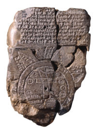
 It all started with The Imago Mundi of 6th century BC Babylonia, the worlds oldest known map – made of clay. I found it in Wikipedia Ancient World Maps.
When traveling we often take it for granted to have access to maps as a guide. Though I’ve never found a map filling all my needs. I guess I never will, the world is just too big!
Luckily I don’t have to carry around one made of clay or stone… *giggles*
Then I got curious of what map sites there is and as usual in the internet, you get overwhelmed with all the information available. Not to mention to get stuck there. Now you know why I didn’t visit you yesterday – I was all around the world!
The biggest online sites to help you find your way around that I found was MapQuest and Maporama, except from Google Maps and Yahoo! Maps, which I guess every one already know of.
However, this got me to look at other maps too – and look what I found! This is only some of them, the ones I liked the most or found unusual or interesting in some way or other.
- National Geographic Map Machine
- The Peters projection map (area accurate)
- The British Library Map Collections
- GB Outline Maps
- US National Atlas Map Maker
- The Atlas of Canada
- Lanic Latin America Maps
- The Map Guide
- The World Fact Book (including maps)
- David Rumsey Historical Map Collection (over 17,400 maps wonderful old maps!)
- A Medieval Atlas – Maps of Scandinavia (including viking routes)
- Historical Maps in Sweden 1630-1928 (update in progress until 2009)
Then my absolute favorite – I fell in love with this one. Yes, it’s possible, at least for me. I think it’s beautiful. Of course I have to think that since it’s an ancient sea map AND of the Nordic countries, the old Scandinavia.
Don’t miss to click on it to zoom in on this map to see the drawings properly!!!!
From Wikipedia: The Carta Marina (Latin: map of the sea or sea map) is the earliest map of the Nordic countries that gives details and placenames. In production for 12 years, the first copies were printed in 1539 in Venice. The map was printed from nine 55×40 cm woodcut blocks to produce a document that is 1.70 m tall by 1.25 m wide.
Think about it: how was it back then? This was in the year of 1539, just TRY to imagine that… We’re definitely spoiled today being able to travel around the world so fast, so easy!
Remember the last time I got stuck like this? That was with Google Earth as a travel tool.
So, where do you think that we shall travel? *giggles*
That is really fascinating! I’ll have to go back and study more of those maps myself. Incredible, isn’t it though?
Jeni Hill Ertmer’s last blog post..Hot Time!
This is really a beautiful blog. Very elegant.
Thanks for the visit.
Cheerio’s last blog post..Grab The Opportunity
What a great collection of maps and way to prepare for travel around the world – also when your Cruising around in Cyber Space!
I sometimes use Google Map to make a map from a place I post about. Maybe I should do that more often.
Thanks for the tips – I’m on my way out there – call me back if I go to far
RennyBA’s last blog post..Scandinavian delight – seafood and fireworks
I learned how to use maps properly when I was in Norway and I learned it from my father there. Because usually I use human maps meaning I ask around alot to get where I want to go. But now with the power of internet it is quite easier to get around
chase’s last blog post..Rewind, Recaps And The Lot Part 1
Excellent post. Thanks for sharing your Sunday studies.
For a reason or another, I’ve loved and studied maps since I was a little boy. Maybe it was my grandfathers collection of old maps from the Baltic Sea (he was from Stockholm) that first caught my interest. All names in the region were given Swedish names. Unfortunately, those maps are gone for ever.
viamichelin.com is also well worth when planning your car trips in most countries
TorAa’s last blog post..Cats on Tuesday – Jan 8 – 2008